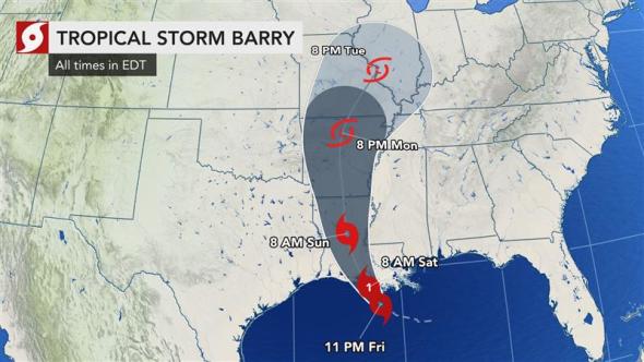
As night fell on the Gulf Coast Friday, Tropical Storm Barry was inching closer toward the Louisiana coastline with 65-mph winds. Barry will be the first tropical system of 2019 to make landfall in the U.S.
Some portions of Louisiana were already experiencing flooding as early as Friday afternoon, according to AccuWeather Extreme Meteorologist Reed Timmer, who was stationed near Chauvin, Louisiana, about an hour south of New Orleans.
Additional strengthening of Barry is forecast prior to landfall Saturday morning. If maximum sustained winds of 74 mph or greater are detected, the storm will be classified as a hurricane.
AccuWeather meteorologists believe that Barry will make landfall as a Category 1 hurricane along the central Louisiana coast.
In New Orleans, neither mandatory nor voluntary evacuations have been ordered, as the city’s mayor, Latoya Cantrell, advised residents to shelter in place. Cantrell said the city only enacts evacuations for hurricanes of Category 3 force or higher, according to the Saffir-Simpson Scale. “Therefore, sheltering in place is our strategy,” the mayor told reporters at a news conference on Thursday.
If Barry maintains the track it’s currently on, the storm could make landfall on Marsh Island, Louisiana, in Vermilion Bay, about 100 miles west of New Orleans.
“The key to whether Barry becomes a hurricane before landfall or not will depend on the amount of time it is able to spend over the warm water of the Gulf of Mexico,” AccuWeather Hurricane Expert Dan Kottlowski said.
Slow forward movement over the Gulf of Mexico on Friday night could allow the storm to reach Category 1 hurricane status just prior to landfall.
However, the main threat from Barry will not be whether or not it is a hurricane at landfall, but rather how much rain is unleashed. Rainfall of 2-4 inches per hour can occur with Barry as it begins to move onshore. Rainfall totals will average 10-18 inches with an AccuWeather Local StormMax™ of 24 inches possible in some places.
Barry’s flooding rainfall to have much more impact than a typical Category 1 hurricane or tropical storm
In terms of impact, AccuWeather has designated Barry a level 2 storm on its RealImpact™ Scale for Hurricanes. The scale ranges from “Less than 1” to a 5, with 5 having the most severe impact.
“Our greatest concern is for torrential rain that would result in life-threatening flooding,” Kottlowski said.
“Heavy, flooding rainfall is expected over a large area, especially over much of eastern Louisiana into parts of western and southern Mississippi and southeastern Arkansas.”
The rainfall amounts assume a steady track. However, should the storm stall over the Deep South, rainfall amounts could be higher.
“This is going to be a significant weather event,” Louisiana Governor John Bel Edwards cautioned in a post on Twitter. It is critical that you monitor updates and heed the advice of local authorities.” Edwards also announced that he’d authorized the Louisiana National Guard to activate up to 3,000 personnel to assist with Barry-related emergencies.
Edwards also implored residents to not attempt to drive on flooded streets and roads. Streets, highways and low-lying areas will be the first to take on water as torrential rain pours down. However, flooding will progress and expand as the storm moves slowly inland.
President Trump on Thursday night in a tweet told Americans FEMA is working closely with state and local officials to prepare for the aftermath and urged residents to “heed the directions of FEMA, State [and] Local Officials.” He added, “Please be prepared, be careful, [and] be SAFE!” as the storm continued gathering strength.
Significant rises on the secondary rivers in the region are likely with the risk of major river flooding including the Pearl, Black, Tickfaw, Comite, Amite and Tchefuncte.
Some secondary rivers, such as the Atchafalaya, generally do not contribute to the flow on the Mississippi in the delta region, but rather take water away from the main stem.
However, as heavy rain falls immediately over the lower part of the main stem of the Mississippi, a rise of a few feet can occur on that waterway. This will be especially true days later over the middle portion of the river, where larger tributaries gather rainfall.
Storm surge to flood coastal communities
Some rise in water is likely along much of the upper Gulf coast, especially along the central and northeastern Gulf coast.
“AccuWeather meteorologists expect a maximum storm surge of 3-6 feet mostly along and just to the right of the storm’s path,” Kottlowski said.
